Good Friday morning everyone–we have a busy day out in front of us so let’s get you caught up on the latest.
1. The severe threat hasn’t changed locally. The highest threat for tornadoes will be to our west from north central Illinois back into Iowa when these storms initially develop. This threat will shift eastward towards us with time so we’re not out of the woods, but our threat IS lower than areas to our west.
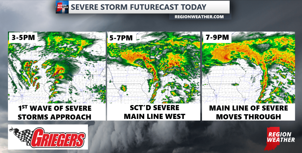
2. It looks like two waves of storms today–an initial line that develops and moves in late this afternoon from the southwest and then a final main line of storms that we’ve been highlighting the last few days. There is still some uncertainty around the first wave but timing would be anytime after 3pm. The main line should arrive later this evening anytime after 7pm. Please stay tuned for timing adjustments as they are often needed with events like this as these storms haven’t even developed yet.
3. Main threat locally is for damaging winds. Hail is also possible and as mentioned earlier we do have a tornado threat in our local environment. Leading up to our storms make sure you secure any loose outdoor “stuff” and charge your phones etc. While not everyone will see severe weather, these storms have the potential to pack quite a punch today, so let’s be ready just in case!
We’ll have LIVE updates as needed this afternoon into tonight as you’d expect. In the meantime, here’s a look at what the radar may look like this afternoon into the evening: