
DAMAGING WINDS, HAIL, HEAVY RAIN MAIN THREATS
As we’ve been talking about since last Thursday, we’re still on track for strong to severe storms later today into the overnight across ALL of NW Indiana. Here’s the latest threat area in coordination with the Storm Prediction Center:

LET’S TALK TIMING:
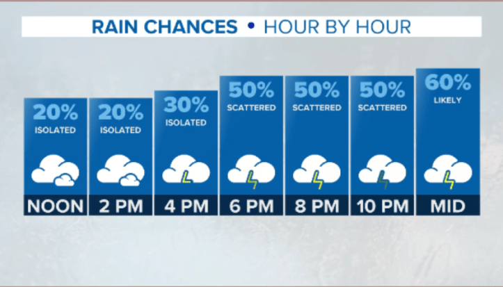
We’ve seen ongoing storms to our west all morning long, but much like last night’s activity, the storms have weakened and stayed west. As of this post, we’re seeing spotty downpours across NWI for your Monday lunchtime, but I’m not expecting them to develop into anything severe. We’ll begin to heat up and will likely see pockets of sunshine this afternoon–this will help showers and storms to erupt along a cold front to our northwest. As a result, our storm chances go up hour-by-hour late this afternoon into the evening:
THE DETAILS:
We’ll likely see a line of showers and storms develop to our west sometime between 4-6pm. It may look something like this:

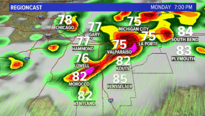
These storms will then head east and gain intensity. I’m thinking after 6pm for our intial round of storms–some of which will likely be wind and hail-makers so we’ll have to watch closely. Here’s what our in-house model is thinking…again, it’s just a computer model but I agree with the placement of the storms this evening:
Beyond the initial round or two of storms, we’ll likely see training thunderstorms somewhere in the Region–or storms that travel over the same spots over and over. While we’ve been very dry as of late, we may be dealing with a flash flood threat late tonight. We’ll also be monitoring this! Here’s our thinking in terms of timing and threats:

We’ll be posting updates as needed to Region Weather on our FB page as needed! It sounds cliche, but make sure you “like” and “follow” us so you get the updates in a timely manner…
