
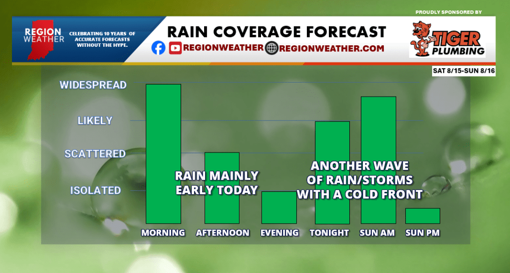
RAIN COVERAGE TODAY AND TOMORROW
Good Saturday morning everyone! This pattern is ALMOST done–we just have a few more waves of rain to get through then we’re home free. For today we have our giant batch of rain this morning–we’re on the northern end of it so it’s not as bad as it is downstate. This batch of rain will begin to push out by afternoon leaving us with mainly dry weather as we see it for the evening. (stray shower can’t be ruled out). Another wave of rain and storms looks likely overnight into early Sunday morning with a cold front before we dry out again later in the day. This front will be the one that clears this entire pattern out of here and brings us our first dry day on radar Monday! We need it across much of the area and entire state.
MUGGYMETER: NEXT 8 DAYS
We’ve had a week straight of thicker humidity around here but that will all change over the next week ahead. Two cold fronts will work through–the first arrives tomorrow morning. Humidity won’t drop immediately. You’ll begin to notice the more comfortable air on Monday–but it will still be a tad humid. The second front Wednesday is the one that works the magic. REAL comfortable air looks to move in Thursday and Friday of next week before humidity bounces back next weekend.

 Region Weather