COLDEST AIR OF THE SEASON
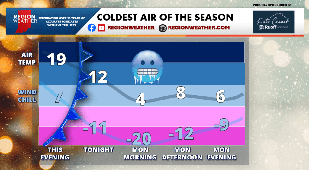
Good Sunday afternoon Region Weather email subscriber family! We have some snow on the way and the coldest air of the season. Yay….(collective groan). Let’s start with the cold.
An arctic front will pass through northwest Indiana sometime around midnight with a transition from cold to frigid. Wind chill values to plummet to -20 by Monday morning with little recovery during the day. This is the type of cold we don’t mess around with–from multiple layers if you’re heading out, to checking those car batteries, and leaving the water dripping in our pipes. You know the drill NWI! Let’s chat numbers and what exists the rest of January into the first week of February coming up in our broadcast at 5pm on our YouTube and Facebook channels.
SNOW & ARCTIC COLD INCOMING
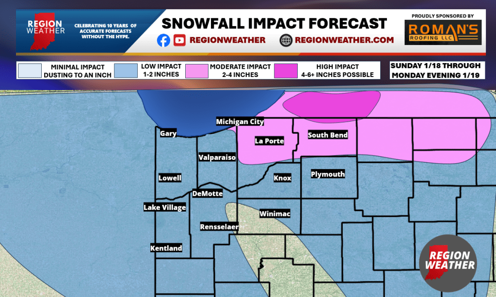
This comes with SOME snow. Not a lot. Remember, these storm systems from the arctic don’t have much moisture (vs next week’s pattern ![]() a tease to our 5pm broadcast today). But that being said, SOME snow still causes issues at the wrong times. Expect snow showers to move in from the northwest this afternoon and continue through the night. Again, not a lot of snow from this–most will settle in the .5 to 1.5 inch range. However, lake snows will takeover to the east and with a westerly fetch off the lake, La Porte county and areas out to the east will see some higher totals with several inches possible by tomorrow evening. On the scale of 1 to big deal, this will fall in the low to middle range for lake effect events in northern Indiana–but don’t get lazy if out traveling tonight or tomorrow!
a tease to our 5pm broadcast today). But that being said, SOME snow still causes issues at the wrong times. Expect snow showers to move in from the northwest this afternoon and continue through the night. Again, not a lot of snow from this–most will settle in the .5 to 1.5 inch range. However, lake snows will takeover to the east and with a westerly fetch off the lake, La Porte county and areas out to the east will see some higher totals with several inches possible by tomorrow evening. On the scale of 1 to big deal, this will fall in the low to middle range for lake effect events in northern Indiana–but don’t get lazy if out traveling tonight or tomorrow!
We’ll chat winter storm potential in the long range at 5pm during our LIVE broadcast. See you soon! Meanwhile here’s our hand-drawn snowfall impact forecast: