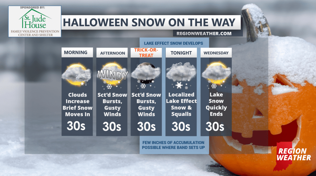
Who’s ready for our first snow of the season? (collective groan…) Ready or not, it’s here and on Halloween none-the-less. This will not be a blockbuster snow by any means, but we have a few opportunities for impacted travel later today into tonight. We’ve covered the timing, amounts, and impacts in detail in our Region Weather LIVE broadcasts the last two nights and the forecast still looks very much on track.
Expect a brief period of snow (for some) later this morning with a break afterwards. This afternoon winds will turn gusty and we’ll develop on and off snow showers and a few squalls capable of producing rapidly reduced visibility and strong, gusty winds. Travel could be briefly impacted this afternoon, but we’re not expecting any noteworthy accumulations until after the sun goes down when it’s much easier for snow to stick and stay.
From Trick-or-Treat into tonight we’ll turn towards lake effect snow as the main system swirls away. With very cold air (-20 degrees C) up above us and relatively warm lake waters–this will ignite a band of lake effect snow which could produce some intense snowfall rates where it sets up.
You know the drill–the lake band will be localized with not much snow elsewhere–but all indication is that it develops from Chicago into perhaps Lake County and then progresses east into Porter and eventually LaPorte County tonight into Wednesday morning before quickly dissipating as high pressure moves in.
A general 1-3 inches is possible across our snowbelt–but if the lake effect band lingers for more than a few hours on any given location, we could see amounts higher than 3 inches.
Happy Halloween! We’ll have updates as needed throughout the day and tonight.